Chur

Chur-Brambrüesch cableway

Chur Bergbahnen im Sommer mit Blick zur Stadt Chur und ins Rheintal
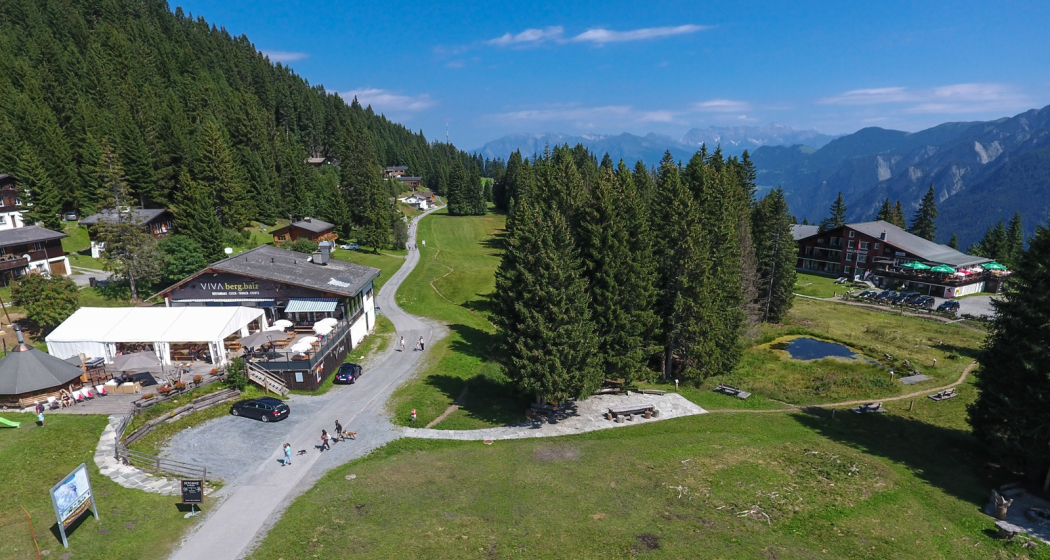
Brambrüesch im Sommer von oben mit Bergrestaurants und Moor Riedboden

Show all 14 images

Chur Bergbahnen (Hausberg Brambrüesch)
The Chur Cableways with its cable car and gondola whisk you from the centre of Chur directly up to the high plateau of Brambrüesch.

Description

Chur is the only city in Switzerland with its own winter and summer sports region, conveniently linked with the city by means of an aerial cableway. Starting point for hiking tours, mountainbike tours and the Alpenbikepark, as well as for ski & snowboard adventures, snowhoeing tours and much more....

Opening hours

WINTER 2023/24

  • Weekend operation: 9. - 17. December 2023
  • Daily: 21. December 2023 - 17. March 2024
  • Weekend operation: 23./24. and 29. March  - 1. April 2024  

Operating hours:

  • First trip aerial cableway 8.30 am
  • Aerial cableway 8.40 am – 5 pm, every 20 min.
  • Ski lift 9 am – 4 pm
  • Chairlift 4 am – 4 pm
  • Chu-Chu train 8.40 am – 4.40 pm
  • Saturday evening operation: 6. January - 2. March 2024, continuous cableway service until 10 pm

 Final check of the slopes at 4.15 pm, after that the slopes are closed.

SPRING / SUMMER / AUTOMN 2024

  • Weekend operation: 6. April - 2. June 2024
  • Public holiday operation: 9./10. May (Ascension/Bridge Day), 20. May (Whit Monday)
  • Daily: 8. June - 20. October 2024
  • Weekend operation: 26./27. October, 1.-3. November 2024 

 Operating hours: 

  • Monday - Friday 8.30 am–4.30 pm
  • Saturday - Sunday 8.30 am–5.00pm
  • Saturday evening operation: 8. June - 31. August 2024, continuous cableway service until 8 pm

Contact

Responsible for this content Brambrüesch.

Mountain Summit Chur

Rote Platte 1506m

Markant: Die Rote Platte von unten gesehen
Aussicht von der Roten Platte
The view from the top of the Rot Platte is breathtaking.

Description

A prominent vantage point that stands out from the middle of the fabled Scaläratobel ravine and is clearly visible as reddish peak from the Chur side. The summit is at 1,506 m and is part of Montalin massif, the main summit of which is 760 meters above the Rote Platte. The second half of the hiking route is pretty steep and the ascent can be quite slippery after it has rained or snowed. The final climb to the summit and the summit itself are exposed and are only advisable for sure-footed hikers with a head for heights. But the view from the summit to Chur and the Rhine Valley is simply breath-taking.

Map

Rote Platte 1506m

Responsible for this content Chur Tourism.

Mountain Summit Untervaz

Calanda 2805m

Calanda 2805m
The Calanda is our Darling and keeps the bad weather away from Chur. That's why the heraldic animal, the ibex, also loves this area. The climbers on the summit toast each other with tapped Calanda Beer.

Description

The Calanda is located northwest of the capital of Graubünden, Chur, and consists of four peaks: Taminser Calanda (2,390 m), Felsberger Calanda (2,697 m), Haldensteiner Calanda (2,805 m, highest point of the city of Chur), and Berger Calanda (2,309 m). It is part of Chur just as its horns are part of an ibex. An animal, by the way, that you might come across on the lower slopes of the Calanda massif if you're lucky. The Swiss Alpine Club SAC's Calandahütte at 2,073 m, which is easily accessible on foot or by bicycle, is popular outing destination. It is the starting point for the hike to the Haldensteiner Calanda and many other exciting tours.

Map

Calanda 2805m

Responsible for this content Chur Tourism.

Mountain Summit Chur

Mittenberg 1114m

Mittenberg
Ausblick vom Mittenberg ins Churer Rheintal

Show all 3 images

Blick auf den Mittenberg und die Stadt Chur
A popular destination for walkers, hikers, joggers and bikers with a magnificent panoramic view.

Description

The Mittenberg is an Alp to the east of the city of Chur. It is idyllically situated on a terrace in a big forest clearing. The Mittenberg offers a magnificent panoramic view of the Chur Rhine valley, the Grison mountains, and far beyond. No wonder that it is a popular outing destination for walkers, hikers, joggers, and bikers. It is easy to cover the 500 meters of altitude from the city to the Mittenberg on a gravel road or numerous forest trails. Once at the top, there's just one thing to do: sit back and enjoy the view. A barbecue area and spring water from the fountain are available.

Map

Mittenberg 1114m

Responsible for this content Chur Tourism.

Mountain Summit Chur

Fürhörnli 1888m

Aussicht vom Fürhörnli auf die Stadt Chur
Fürhörnli von unten (Mittenberg)
A breathtaking view from the top over the city of Chur and the surrounding Rhine Valley.

Description

The Fürhörnli juts on 1'888 m like a balcony out into the abyss and offers a splendid panorama view on the Alpine City of Chur and the surrounding Rhine valley. The branch-off to the Fürhörnli peak is not marked, but the tracks left from the hiking route are well recognizable. Along the tree-covered ridge you reach the Fürhörnli in a few steps. Be careful on the small and exposed peak-balcony (accession only recommended for people free from giddiness).

Map

Fürhörnli 1888m

Responsible for this content Chur Tourism.

Mountain Summit Domat/Ems

Dreibündenstein 2160m

Dreibündenstein
Dreibündenstein im Winter
The hiking and snow shoe region between the three areas of Chur-Brambrüesch, Feldis and Pradaschier is characterized by the picturesque high plateau around the Dreibündenstein.

Description

The Dreibündenstein, «Term bel» in Romansh, located in the alpine area of the present municipalities of Domat/Ems, Scheid, and Malix, is a peak, plateau, and historical border point all in one. In the heart of the Chur, Lenzerheide, and Viamala regions, it connects the three summer and winter sports areas Brambrüesch, Pradaschier, and Feldis. At an altitude of 2,160 m, a stone monument marks the shared border point of three former Rhaetian states and commemorates the freedom fighters of Graubünden. The place offers a magnificent panoramic view of the mountain ranges of the UNESCO World Heritage Tectonic Arena Sardona, the Graubünden mountains, and far beyond.

Map

Dreibündenstein 2160m

Responsible for this content Brambrüesch.