discover.swiss ID
osm_1684135
discover.swiss Additional Type
City

Catholic Church Rhäzüns

Church Sogn Gieri Rhäzüns

Kirche Sogn Gieri Rhäzüns
The church Sogn Gieri (Rhaeto-Romanic in the idiom Sursilvan for St. George) is a small church outside the village of Rhäzüns.

Description

The Church of S. Gieri / St. Georg between Bonaduz and Rhazuns was probably the old parish church of both places and is a very special treasure. The oldest building is according to archaeological finds from the 6/7 Century date. In the second Quarter of the 14th Century brought a new choir, and then the interior was equipped with magnificent paintings. Clients were probably the Barons of Rhazuns. A first unknown artist took over the decoration of the chancel, the east wall (it shows the legend of St. George), and a dragon fight and a donor picture on the long north side. From a second, also not particularly well-known artist, the remaining north wall were the West and south walls provided with scenes from the Old and New Testaments, as well as with painted saints stories. For more information about these historic buildings can be found on the website of the parish Rhazuns.

Opening hours

Daily from 8am-7pm (door closes automatically)

Contact

Responsible for this content Chur Tourism.

Catholic Church Rhäzüns

Church Sogn Paul Rhäzüns

Kirche Sogn Paul Rhäzüns
The church Sogn Paul stands slightly elevated at the edge of the village of Rhäzüns.

Description

The former parish and current cemetery church Sogn Paul is slightly increased, at the southwestern edge of the village, at the foot of the spur of the Heinz mountain. The striking building with einschiffigem nave and a rectangular choir is covered by a single pitched roof.

 The authentic medieval interior is the stage for works of art from four centuries to enter into a dialogue with each other.

Sogn Paul was a medieval parish church that was expanded by a baroque nave and the cemetery for the Barons of Rhäzüns Inside there are remnants of frecoes by the Master of Waltensburg and by a workshop of the "Gotico Internazionale". The alter is decorated by post-Gothic papier-maché copies of the alter wings of Sogn Gieri.

Opening hours

Daily from 8am-7pm (door closes automatically)

Contact

Responsible for this content Chur Tourism.

Viewpoint Rhäzüns

Rhäzünser Alp

Ausblick von der Rhäzünser Alp ins Churer Rheintal und auf den Calanda
Rhäzüns Alp Sura

Description

The Sura Alp - also known as Rhäzünser Alp - stands at 1760 metres above sea level above Rhäzüns. There are 1250 meters of altitude to overcome from the village to the alp. The panoramic view of the Vorab, the Tschingelhörner, the Ringelspitz, the Calanda, and the Rhine valley near Chur, as well as the Safier and Domleschg mountains make this climb well worth the effort. The Rhäzünser Alp can be reached via hiking trails or on rewarding mountain bike tour, which is sign posted by the official number 262.

Map

Rhäzünser Alp

Responsible for this content Chur Tourism.

Medium
23 km
2:30 h
1150 mhd
1150 mhd
Alp Sura Calanda
Alpr Sura Lagmiert

Show all 4 images

Panorama Alp Sura Flimsberg
This tour is certainly an experience, featuring a tasty ascent up to the Rhäzünser Alp Sura, wonderful panoramic views of the mountain scenery around Flims, the Calanda and the Graubünden Rhine valley, followed by a fast-flowing descent on single trails.
Technique /6
Fitness 4/6
Highest Point   m
Lowest Point   m
Best Season
Jan
Feb
Mär
Apr
Mai
Jun
Jul
Aug
Sep
Okt
Nov
Dez
Start
Rhäzüns
Destination
Rhäzüns
Coordinates
46.799042540309, 9.3991089621148

Details

Description

From the railway station at Rhäzüns the route takes us along the Alpstrasse up to the Rhäzünser Alp Sura. There are several village fountains along the way, ideal for topping up those water bottles with good, fresh Rhäzüns water in preparation for the ascent. As the unsurfaced track continuously winds its way upwards, it's a sweat-inducing ascent that calls on reserves of endurance. Once we have passed the culms da razén (Rhäzüns pasture huts), we deserve a short break at the Lag Miert mountain lake. From its idyllic high-plateau setting, the small lake radiates peace and tranquillity, strengthening our resolve before we tackle the final and somewhat flatter ascent to the Rhäzünser Unteralp. By the time we hear the welcome shrieks of the marmots we know we have reached the highest point on the tour, the Alp Sura (Rhäzünser Oberalp). We are amply rewarded for our efforts on the ascent with stunning panoramic views of the Vorab, the Tschingelhörner, the Ringelspitz and the Calanda, the Rhine valley around Chur, and the Safier and Domleschg mountains. The downhill run begins gently enough along the Alpstrasse to the Bonaduzer Alp il Bot. Then it really begins to gather pace at the branch-off after Scardanal before turning technical on the single trail after Salums and Prau Videun. It's a real treat, with a fast-flowing run back down to Rhäzüns.

Directions

Rhäzüns - Mulin Sura - Rhäzünser Alp Sut - Rhäzünser Alp Sura - Alp il Bot - Scardanal - Salums - Prau Videun - Figiu - Puleras - Rhäzüns

Directions

Public Transport

By train to Rhäzüns.

Anreise Information

Take the A13/E43 in the direction of Chur and to Rhäzüns.

Responsible for this content SwitzerlandMobility.
This content has been translated automatically.

Geschlossen
Medium
18 km
1:15 h
300 mhd
300 mhd
Rheinauen Ufer
Kirche Sogn Gieri Chor

Show all 4 images

Panorama Rheinauen
This pleasant mountain bike tour takes you along the Rhäzünser Rheinauen and features unique views of these wetlands of national importance. It also takes in a visit of the church at Sogn Gieri, famous for its murals, considered unrivalled by art historians.
Technique /6
Fitness 2/6
Highest Point   m
Lowest Point   m
Best Season
Jan
Feb
Mär
Apr
Mai
Jun
Jul
Aug
Sep
Okt
Nov
Dez
Start
Rhäzüns
Destination
Rhäzüns
Coordinates
46.799042540309, 9.3991089621148

Details

Description

From the railway station at Rhäzüns we soon reach the water's edge, our nostrils filling with the fresh air from the wetlands. The Rhäzünser Rheinauen are among the most best preserved wetland areas in Switzerland and are considered of national importance. We continue along the single trail as it rises and falls until we reach the flatter section along the Rhine dam after Rothenbrunnen. Along the Polenweg to Reichenau the sparse forest lets us glimpse wonderful views of these unique Rheinauen wetlands. Along this section of the route the Hinterrhein meanders from one side of the valley to the other. In Reichenau, the confluence of the Hinterrhein and Vorderrhein, we once again switch to the other side of the river and roll on towards Bonaduz. After a short, steep ascent up to the high plateau of Rhäzüns and Bonaduz the route continues past Sogn Gieri (St. Georg), which is well worth a stop. The Romanesque church, more than 1,000 years old, is famous beyond Switzerland's borders for its astonishing and beautifully preserved murals. After the rewarding visit of Sogn Gieri we happily cycle back to Rhäzüns.

Directions

Rhäzüns - Saulzas - Undrau - Rothenbrunnen - Polenweg - Schafweide - Stn. Reichenau-Tamins - Nulez - Plazzas - Sogn Gieri - Rhäzüns

Directions

Public Transport

By train to Rhäzüns.

Anreise Information

Take the A13/E432 in the direction of and to Rhäzüns.

Responsible for this content SwitzerlandMobility.
This content has been translated automatically.

Simple
13 km
2:10 h
360 mhd
360 mhd
Rundtour Bonaduzer Wald 256
256 Bonaduzer Wald

Show all 17 images

256 Bonaduzer Wald
This tour opens up to magnificent views of the imposing Rhine Gorge. From Bonaduz the route passes through beautiful forest paths into the Rhine Gorge and back again.
Technique /6
Fitness 2/6
Highest Point   m
Lowest Point   m
Best Season
Jan
Feb
Mär
Apr
Mai
Jun
Jul
Aug
Sep
Okt
Nov
Dez
Start
Bonaduz
Destination
Bonaduz
Coordinates
46.810512104199, 9.3977179167695

Details

Description

The starting point of this mountain bike tour is the village of Bonaduz, which together with Rhäzüns forms an actual high plateau. Bonaduz is also the gateway to the Rhine Gorge Natural Monument.

After crossing the idyllic forest landscape near Bonaduz on well-maintained forest paths, an ascent follows on a road with little traffic, which leads to Sigl'Ault with great views. This is soon followed by a single trail that leads smoothly down to the panoramic road above the Rhine Gorge. The "Ruinaulta", as the gorge is called in Romansh, is one of the most magnificent and diverse landscapes in the Alps, which was formed by a landslide 10,000 years ago. You follow this road with a magnificent view down below, past the "Zault" viewing platform (photo stop recommended), before finally diving back into the forests and driving back to Bonaduz on extensive forest paths.

Geheimtipp

This route is usually drivable early in the year until late in autumn.

Sicherheitshinweis

Watch out for hikers. In the canton of Graubünden we share the paths.

Ausrüstung

Repair and first aid kit belong in the rucksack

Directions

This route is only signposted in one direction: Bonaduz – Sigl Ault – Zault.

Directions

Public Transport

Stop: Flims Dorf, mountain railways
By post bus from Chur or the public Flims Laax Falera Shuttle.

Timetable
www.sbb.ch

Anreise Information

By car on the A13 motorway from Zurich to Chur, exit 18 Reichenau

Parking

You will find parking spaces in Bonaduz at the railway station.

Responsible for this content Flims Laax Falera Management Ltd..
This content has been translated automatically.

Outdooractive Logo

This website uses technology and content from the Outdooractive platform.

Catholic Church Rhäzüns

Church Sogn Gieri Rhäzüns

Kirche Sogn Gieri Rhäzüns
The church Sogn Gieri (Rhaeto-Romanic in the idiom Sursilvan for St. George) is a small church outside the village of Rhäzüns.

Description

The Church of S. Gieri / St. Georg between Bonaduz and Rhazuns was probably the old parish church of both places and is a very special treasure. The oldest building is according to archaeological finds from the 6/7 Century date. In the second Quarter of the 14th Century brought a new choir, and then the interior was equipped with magnificent paintings. Clients were probably the Barons of Rhazuns. A first unknown artist took over the decoration of the chancel, the east wall (it shows the legend of St. George), and a dragon fight and a donor picture on the long north side. From a second, also not particularly well-known artist, the remaining north wall were the West and south walls provided with scenes from the Old and New Testaments, as well as with painted saints stories. For more information about these historic buildings can be found on the website of the parish Rhazuns.

Opening hours

Daily from 8am-7pm (door closes automatically)

Contact

Responsible for this content Chur Tourism.

Catholic Church Rhäzüns

Church Sogn Paul Rhäzüns

Kirche Sogn Paul Rhäzüns
The church Sogn Paul stands slightly elevated at the edge of the village of Rhäzüns.

Description

The former parish and current cemetery church Sogn Paul is slightly increased, at the southwestern edge of the village, at the foot of the spur of the Heinz mountain. The striking building with einschiffigem nave and a rectangular choir is covered by a single pitched roof.

 The authentic medieval interior is the stage for works of art from four centuries to enter into a dialogue with each other.

Sogn Paul was a medieval parish church that was expanded by a baroque nave and the cemetery for the Barons of Rhäzüns Inside there are remnants of frecoes by the Master of Waltensburg and by a workshop of the "Gotico Internazionale". The alter is decorated by post-Gothic papier-maché copies of the alter wings of Sogn Gieri.

Opening hours

Daily from 8am-7pm (door closes automatically)

Contact

Responsible for this content Chur Tourism.

E-bike Domleschg castle tour

Geschlossen
Medium
61.3 km
4:25 h
618 mhd
618 mhd
Burg Castelberg
Schloss Ortenstein bei Tomils

Show all 8 images

Paspels mit Schloss Sins
An impressive circular tour through the Domleschg valley south of Chur, which is characterised by rolling hills, orchards and numerous castles.
Technique 2/6
Fitness 3/6
Highest Point  805 m
Lowest Point  564 m
Best Season
Jan
Feb
Mär
Apr
Mai
Jun
Jul
Aug
Sep
Okt
Nov
Dez
Start
Station Chur
Destination
Station Chur
Coordinates
46.853236, 9.529987

Details

Description

Along the right bank of the Rhine via Felsberg and Tamins, this tour first leads to Reichenau, where the confluence of the Vorderrhein and Hinterrhein is located, which can be seen impressively from the bridge. The tour continues picturesquely over the plateau of Bonaduz and Rhäzüns until you finally reach the Domleschg at Rothenbrunnen. Now follows a magnificent round tour through the southern-looking valley, which is characterized by rolling hills, orchards and numerous castles. A landscape that invites you to explore it on an e-bike. Again and again, the view sweeps over impressive castles, palaces and castle ruins - from Juvalt Castle near Rothenbrunnen to Hohen Rätien Castle near Sils, they characterize the Domleschg landscape. Lake Canova near Paspels invites you to take a refreshing dip in the water (bathing season from May to mid-October). The trail continues along the Polenweg with a view of the Rhäzünser Rheinauen, which are among the most intact floodplain landscapes in Switzerland and are of national importance. Behind the golf course of Domat/Ems with a view of the "Tumas" (the striking hills that originate from landslides and are under nature protection) then follows the last stretch back to the Alpine City of Chur. 

Directions

From Chur on the Rhine route 2 to Bonaduz. There ride across the plateau to Rhäzüns and along the road to Rothenbrunnen. Now follow the Graubünden Route 6 to Thusis and on to Sils. The return journey then follows through the hilly landscape along the castles and via Canova Lake back to Rothenbrunnen. From there on the Graubünden Route 6 back to Chur.

Directions

Public Transport

Chur train station is easily accessible by SBB (Swiss Federal Railways), Rhaetian Railways, Postbus or Chur Bus.

Anreise Information

Motorway exit Chur Nord or Chur Süd and then drive to the city centre.

Parking

At Chur railway station two multi-storey car parks are available (Otto & Alex / SBB Park & Rail).

Responsible for this content Graubünden Ferien.

Castle Rhäzüns

Rhäzüns Castle

Schloss Rhäzüns
While other castles hoard only as ruins on their heights, this castle has survived into the present in an almost intact form.

Description

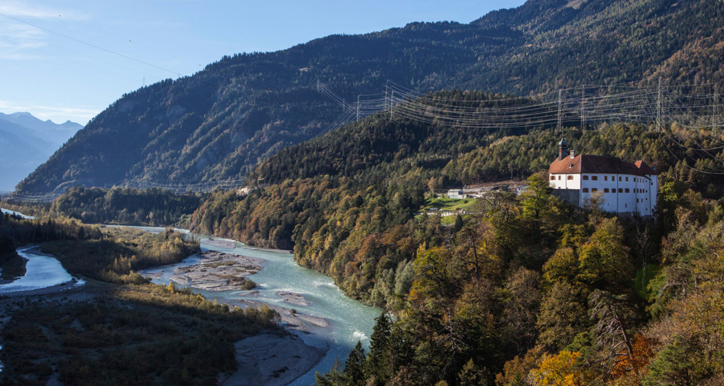
On a steep promontory over the Hinter Rhine lies the stately Rhäzüns castle (first documented 1288), which once guarded the passage into Domleschg valley. It is the first of a whole sequence of castles and fortresses lining the hills along the Hinter Rhine. During the Middle Ages, Rhäzuns castle was home to the powerful house of Rhäzüns. Today, it is owned by the Ems Group. 

Until today, many of the medieval elements of the building have been retained, especially in the main walls and the foundations. But its overall appearance dates back to the 16th and 17th centuries. The decoration of facades and interior give the castle significant historical, cultural and artistic importance and a unique character.

Rhäzüns castle is not open to the public.

Contact

Rhäzüns Castle

7403 Rhäzüns

Responsible for this content Chur Tourism.